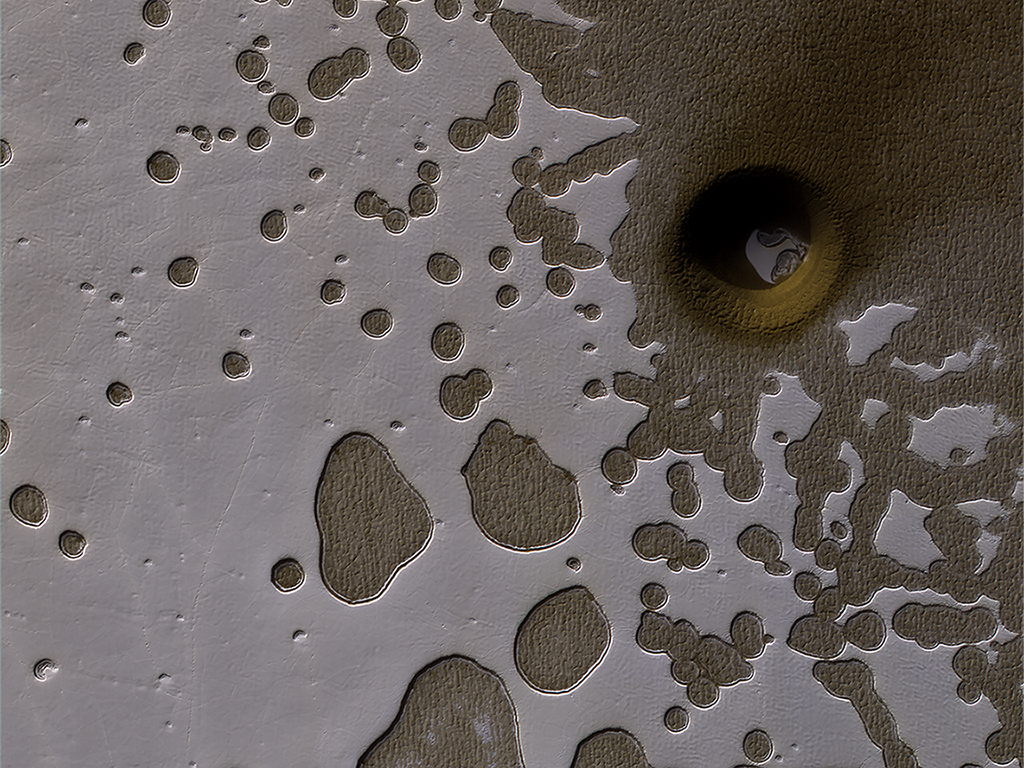
Seen from space, regions of Mars around the south pole have a bizarre, pitted “Swiss cheese” appearance. These formations come from alternating massive deposits of CO2 ice and water ice, similar to different layers of a cake. For decades, planetary scientists wondered how this formation was possible, as it was long believed that this layering would not be stable for long periods of time.
But in 2020, Peter Buhler, a Research Scientist at the Planetary Science Institute, and a team of researchers figured out the dynamics of how the Swiss cheese-like terrain formed: it was due to changes in Mars’ axial tilt that caused changes in the atmospheric pressure, which alternately produced water and CO2 ice. But they were only able to deduce the rate of CO2 and water deposits over millions of years, which is about ten times longer than Mars’ orbit cycles.

The HiRISE camera on NASA’s Mars Reconnaissance Orbiter captured this unusual crater or pit on the surface of Mars. Frozen carbon dioxide gives the region its unique “Swiss cheese” like appearance. Image:NASA/JPL/University of Arizona
Now, in a follow up study, Buhler was able to model how the frozen carbon dioxide and water deposits gro
w and shrink over 100,000 year-long cycles of Mars’s polar tilt. The model allowed the researchers to determine how water and carbon dioxide have moved around on Mars over the past 510,000 years.

Mars’ south polar ice cap. Credit: ESA / DLR / FU Berlin /
“Mars experiences 100,000-year cycles in which its poles vary from tilting more toward or away from the Sun, Buhler said, in a press release. “These variations cause the amount of sunlight shining on each latitude band, and thus the temperature of each band, to cycle, too. Water ice moves from warmer to colder regions during these cycles, driving Mars’ basic long-term global water cycle.”
The layered deposits of H2O and CO2 ice can provide a record Mars’ climate history, as the south polar ice cap is the only place on the Red Planet where frozen carbon dioxide persists on the surface year-round.
“This layering is important because it is a direct record of how water and carbon dioxide have moved around on Mars,” Buhler said. “The water layer thicknesses tell us how much water vapor has been in Mars’ atmosphere and how that water vapor has moved around the globe. The carbon dioxide layers tell us the history of how much of the atmosphere froze onto the ground, and thus how thick or thin Mars’ atmosphere was in the past.”
Buhler explained that knowing the history of Mars’ atmospheric pressure and availability of water are critical to understanding the basic workings of Mars’ climate and near-surface geologic, chemical, and perhaps even biologic history.
“Before this study, the rate at which water moves through this cycle has been highly uncertain,” he said. “This study addresses this open question by deciphering the layered ice record in Mars’ south polar cap.”

Exotically pitted “Swiss-cheese” terrain made of carbon dioxide (dry ice) overlies the topmost layer of water ice in Mars’ South Polar Massive Carbon Dioxide Ice Deposit. Image is about 1 kilometer across. Credit: NASA/JPL-Caltech/UArizona.
Buhler created a numerical model to simulate the build-up of the layers over time and ran the model approximately one billion times, “each time using a different governing function of H2O ice deposition as a function of Mars’ orbital configuration,” he wrote in his paper, published in Geophysical Research Letters.
What he found that best recreates the observed sequence of layering at Mars south pole was that the amount of H2O ice decreased when the axis tilt of the planet increased and vice versa. Buhler said his results “provide a major step forward for deciphering the basic workings of Mars’ water cycle and, by extension, the long-term availability of near-surface water ice or even liquid brines. The availability of near surface water sources is critical for enabling near-surface life as we know it.”
Source: universetoday.com


