
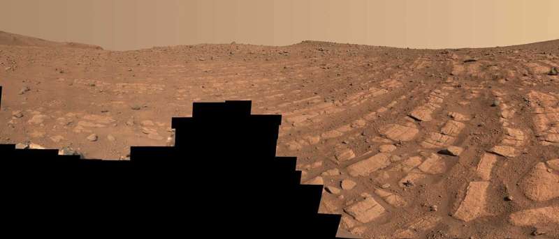
Scientists think that these bands of rocks may have been formed by a very fast, deep river – the first of its kind evidence has been found for on Mars. NASA’s Perseverance Mars rover captured this scene at a location nicknamed “Skrinkle Haven” using its Mastcam-Z camera between Feb. 28 and March 9, 2023. Credit: NASA/JPL-Caltech/ASU/MSSS

New images taken by NASA’s Perseverance rover may show signs of what was once a rollicking river on Mars, one that was deeper and faster-moving than scientists have ever seen evidence for in the past. The river was part of a network of waterways that flowed into Jezero Crater, the area the rover has been exploring since landing more than two years ago.
Understanding these watery environments could help scientists in their efforts to seek out signs of ancient microbial life that may have been preserved in Martian rock.

Perseverance is exploring the top of a fan-shaped pile of sedimentary rock that stands 820 feet (250 meters) tall and features curving layers suggestive of flowing water. One question scientists want to answer is whether that water flowed in relatively shallow streams—closer to what NASA’s Curiosity rover has found evidence of in Gale Crater—or a more powerful river system.
Stitched together from hundreds of images captured by Perseverance’s Mastcam-Z instrument, two new mosaics suggest the latter, revealing important clues: coarse sediment grains and cobbles.
“Those indicate a high-energy river that’s truckin’ and carrying a lot of debris. The more powerful the flow of water, the more easily it’s able to move larger pieces of material,” said Libby Ives, a postdoctoral researcher at NASA’s Jet Propulsion Laboratory in Southern California, which operates the Perseverance rover. With a background in studying Earth-based rivers, Ives has spent the last six months analyzing images of the Red Planet’s surface. “It’s been a delight to look at rocks on another planet and see processes that are so familiar,” Ives said.
Following the curves
Years ago, scientists noticed a series of curving bands of layered rock within Jezero Crater that they dubbed “the curvilinear unit.” They could see these layers from space but are finally able to see them up close, thanks to Perseverance.
One location within the curvilinear unit, nicknamed “Skrinkle Haven,” is captured in one of the new Mastcam-Z mosaics. Scientists are sure the curved layers here were formed by powerfully flowing water, but Mastcam-Z’s detailed shots have left them debating what kind: a river such as the Mississippi, which winds snakelike across the landscape, or a braided river like Nebraska’s Platte, which forms small islands of sediment called sandbars.

When viewed from the ground, the curved layers appear arranged in rows that ripple out across the landscape. They could be the remnants of a river’s banks that shifted over time—or the remnants of sandbars that formed in the river. The layers were likely much taller in the past. Scientists suspect that after these piles of sediment turned to rock, they were sandblasted by wind over the eons and carved down to their present size.
“The wind has acted like a scalpel that has cut the tops off these deposits,” said Michael Lamb of Caltech, a river specialist and Perseverance science team collaborator. “We do see deposits like this on Earth, but they’re never as well exposed as they are here on Mars. Earth is covered in vegetation that hides these layers.”
A second mosaic captured by Perseverance shows a separate location that is part of the curvilinear unit and about a quarter mile (450 meters) from Skrinkle Haven. “Pinestand” is an isolated hill bearing sedimentary layers that curve skyward, some as high as 66 feet (20 meters). Scientists think these tall layers may also have been formed by a powerful river, although they’re exploring other explanations, as well.
“These layers are anomalously tall for rivers on Earth,” Ives said. “But at the same time, the most common way to create these kinds of landforms would be a river.”
The team is continuing to study Mastcam-Z’s images for additional clues. They’re also peering below the surface, using the ground-penetrating radar instrument on Perseverance called RIMFAX (short for Radar Imager for Mars’ Subsurface Experiment). What they learn from both instruments will contribute to an ever-expanding body of knowledge about Mars’ ancient, watery past.
“What’s exciting here is we’ve entered a new phase of Jezero’s history. And it’s the first time we’re seeing environments like this on Mars,” said Perseverance’s deputy project scientist, Katie Stack Morgan of JPL. “We’re thinking about rivers on a different scale than we have before.”


